Customizable 3D Renderer Framework for visualizing geospatial data including CDB Common Database.
3DViewer
GAJ Geospatial Enterprises has created a flexible viewer application for viewing geospatial data in 3D which includes the capability to view CDB.
This application can make use of a myriad of sources available for visualization within the constraints that the application providing the capability must simplify process for the
end user to the maximum extent possible. The viewer shown below allows the user to configure the view he needs from many sources including OGC Web Services by selecting the imagery,
elevation, and feature sources he wished to display or he may simply select a CDB and enable layers from the CDB.. The viewer is built upon the osgEarth Library and makes use of the
CDB plugin described here.For a complete list of open source software used in the project see
here.Propriatary vender APIs used in the product can be found here.
For questions about the 3D Viewer not answered on this page feel free to contact us here.
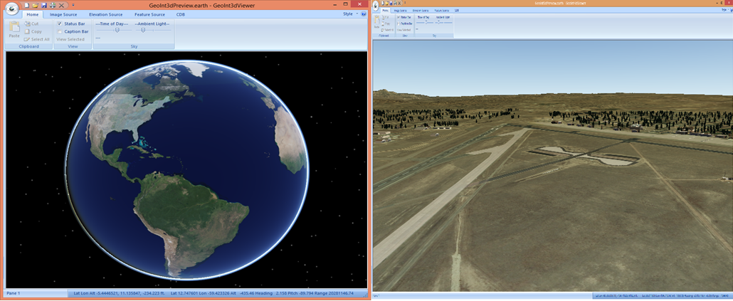
The Left Image above shows a global view of CDB in the viewer while the view on the right shows USSOCOM’s industry example CDB of Colorado Springs.
This 3D viewer is designed to be a starting point for building a custom visualization solutions. The basic interface for providing these solutions is shown below.
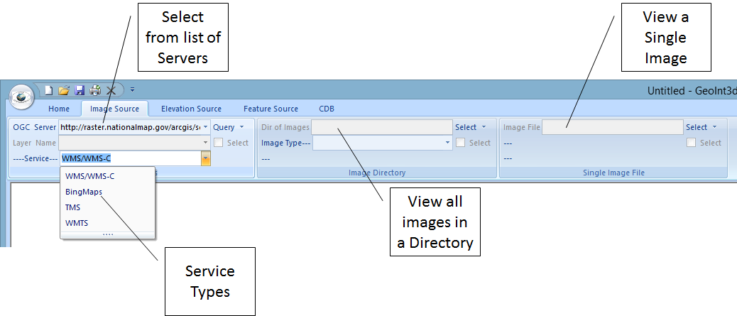
The image source panel shown in above allows the user to select from a number of different OGC Image Service types as well as Bing Maps. A list of servers of each service
type are selectable. The selections are all driven from xml files which are user configurable. Once a server is selected it will be queried for a list of layers it provides
and the layers then become selectable in the viewer. The user then may select a layer to display from the available layers provided by the server. In addition the user may
select to view a directory of images on the local system or a single image. If a directory is selected then an image type to view must also be selected.
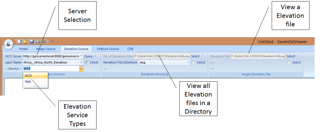
Elevation may be added to the view by selecting an elevation source on the Elevation source panel. While image services are fairly ubiquitous elevation data is less so. There
are many services that serve elevation as a Web Mapping System (WMS) layer the image is a shaded elevation image and not actual elevation data. This data may be selected and
viewed from the Image Source panel but not used as an elevation layer. There are some services available however that server actual elevation information using Web Coverage Service (WCS)
or Tiled Mapping Service (TMS). The open source GeoServer capability or ESRI products may be utilized to create WCS or TMS services for an organization that the viewer can utilize.
Elevation can also be incorporated into the view as either a director of elevation files or as a single elevation file. If a directory of files is selected then the file type of the elevation
data must be selected as well.
You can find GeoServer here. Link to GeoServer
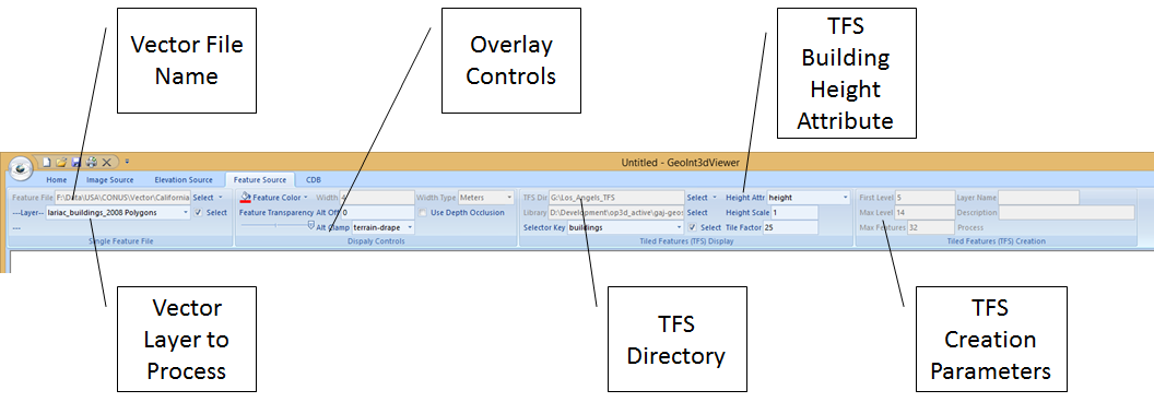
Feature overlays for the view can be selected on the Feature source panel. The image above shows the options available on this panel. A vector file (I.E. ESRI Shape file or GeoPackage
vector data) may be selected and used to overlay the lineal or polygonal information defined in the file on the imagery and elevation. If building foot print information for an area
is available it can be used to create a Tiled Feature Set (TFS) which will allow buildings to be procedurally created in the scene in a geotypical form when selected.
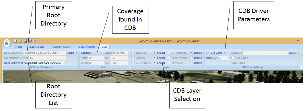
The CDB panel allows the user to select the topmost directory of a CDB and once it is selected layers of the CDB may be enabled for viewing. The coverage that a CDB represents can
be generated and stored in a local xml file. The coverage xml also contains information about layers present in the CDB so it must be generated at least once before utilizing the CDB
as a view source. To generate the coverage xml simply press the Generate button after selecting the root CDB directory. Once the coverage is present available layers in the CDB may be
selected for viewing. (Note at present while RoadNetwork and PowerLine layers have support in the viewer these layers have not been incorporated in the CDB drivers and will not display
until this software has been developed) Layers of CDB may be selected along with selections from the other panels. For instance one could select CDB Geo-Specific and Geo-Typical Feature
data along with TFS elevation source from the Elevation Source panel and one of the Bing Map Image layers from the Image Source panel and then render that selection in the viewer.
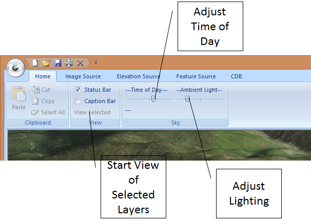
Once the selections have been made on any/or all of the above panels have been made the data can be viewed by pressing the View Selected button on the Home Panel. Once the view is
initialized the Time of Day and Ambient Light may be used to adjust the view and the mouse may be used to position and move the view.
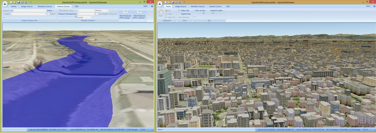
The images above illustrate some of the viewer capabilities on the right image which uses CDB for the imagery and elevation layers and a TFS building set built on the Feature panel
from Los Angeles Building footprint data. The image on the left is built using a single image and one-meter elevation file with a shapefile overlay of Tonawanda Creek in Batavia NY.
The water level can be adjusted in order visualize a specific water level based on a flood gauge reading.